|
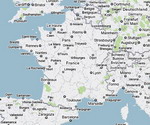
Normandy is a geographical region corresponding to the former
Duchy of Normandy. It is situated along the English Channel coast of
Northern France between Brittany (to the west) and Picardy (to
the east) and comprises territory in northern France and the Channel
Islands. Normandy is divided between French and British sovereignty.
The continental territory under French sovereignty covers 30,627
km² and forms the preponderant part of Normandy and roughly 5% of
the territory of France. It is divided for administrative purposes into
two régions: Basse-Normandie and Haute-Normandie. The Channel Islands
(referred to as Îles Anglo-Normandes in French) covers 194 km²
and comprise two bailiwicks: Guernsey and Jersey, which are
British Crown dependencies.
Upper
Normandy (Haute-Normandie) consists of the French départements of
Seine-Maritime and Eure, and Lower Normandy (Basse-Normandie) of the
départements of Orne, Calvados, and Manche. The former province of
Normandy comprised present-day Upper and Lower Normandy, as well as
small areas now part of the départements of Eure-et-Loir, Mayenne, and
Sarthe.
|