|
Search
this site

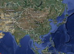
View
map of Asia
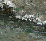
View
map of Nepal
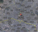
View
map of Kathmandu
Copyright © All World
Vacation Station
|
 |
A
Short Stay In Kathmandu
Experience
the beauty of the Annapurna region of Nepal
Volunteering
In Nepal: An Unforgettable Experience
Experience
the beauty of the Annapurna region of Nepal by Julien
Kathmandu
Hotels
Annapurna Travel guide
The Annapurna region lies
in central Nepal. Named after the Hindu goddess Annapurna (the bestower
of food), who is regarded as a manifestation of goddess Parvati, the consort
of Lord Shiva. The chief mountains in this region include the Dhaulagiri,
Annapurna and Manaslu Himal. The Annapurna Himal, which lies between the
Kali Gandaki and Marsyangdi river valley, forms a solid mountain bastion.
It covers a distance of 40 miles and encompasses within its range some
twelve peaks that rise to an elevation of more than 7000m and numerous
other lesser peaks.
Climate, Flora & Fauna
The climate in the Annapurna
region varies from subtropical to alpine. The southern slopes of the area
has the highest rainfall rate in the country- 3000mm per year, whereas
the northern slopes lying in the rain shadow has the lowest rate - less
than 300mm per year.
| The difference in
the climatic conditions in this region is responsible for its varied flora
and fauna. The Annapurna region possesses a variety of flora and fauna.
It stretches from the subtropical lowlands and the high temperate rhododendron
forest in the south, to a dry alpine steppe environment in the North. The
Southern lowlands are lush with subtropical forests consisting of chirpine
and alder. In the Northern highlands temperate forests of oaks, rhododendron,
fir, and blue pine are found. The wet regions yield a variety of bamboo
species. The higher altitude further North give rise to forests of birch,
blue pine and juniper trees, which are replaced by juniper and rhododendron
in the far North. In the semi-desert rain shadow region, behind the Himalayas,
bushes of caragana and juniper species are evident. It has several species
of wildlife. |

Buy
This Allposters.com
|
There are around four hundred
and seventy-four species of birds, and around a hundred species of mammals.
The Annapurna region serves as an excellent habitat for rare and endangered
mammals like the snow leopard, musk deer, blue sheep, red panda and many
of Nepal's brilliantly plumaged pheasants

Buy
This Allposters.com
|
Annapurna peaks
The Annapurna massif contains
six major peaks over 7,200 m: Annapurna I(8091m), Annapurna II(7937m),
Annapurna III(7555m), Annapurna IV(7525m), Gangapurna(7455m) and Annapurna
South(7219m). Annapurna I, standing at a height of 8,091 m, is the tenth
highest summit in the world. It is located east of a great gorge cut through
the Himalaya by the Kali Gandaki River, which separates it from the Dhaulagiri
massif Annapurna was the first 8000m peak scaled by a climber. Till 1948,
Nepal was closed to all foreigners. It was in the year 1949 that the kingdom
opened its doors to mountaineers .In that year two foreign teams received
permission to enter the country, one Swiss and another American. In 1950,
a French mountaineering team led by Maurice Herzog succeeded in climbing
Annapurna, an 8000m peak. They had no information about the peak they would
climb. With little or no information, they decided to take on the Annapurna.
On 3rd June, Maurice Herzog and Louis Lachenel reached the summit of Annapurna
I, after climbing for eight hours. |
They had to suffer from
severe frostbite which cost Maurice Herzog his toes and fingers. Herzog
has written about the climb in his book The Conquest of Annapurna 1950.
In 1957 Wilfred Noyce and
David Cox climbed Machapuchhre (6997m) to within 50m of its summit. After
this attempt, the government prohibited further climbing on the mountain.
So technically Machapuchre remains unclimbed.
| Annapurna II, the
eastern anchor of the range, was first climbed in 1960 by a British/Indian/Nepalese
team led by Jimmy Roberts, via the West Ridge, approached from the north.
Annapurna III was first climbed in 1961 by an Indian expedition team led
by Mohan Kohli. The summit party comprised Mohan Kohli, Sonam Gyatso, and
Sonam Girmi. They climbed from the Northeast Face.
Tharpu Chuli (Tent Peak),
shaped like a tent, at 5663m is an ideal peak for a short expedition. Lying
across the Annapurna glacier, the peak offers excellent views of its neighbouring
peaks from its summit. Pisang Peak (6091m) forms part of the Manang Himal.
Towering above the Marshyangdi valley, this peak was first ascended by
J.Wellenkamp, a German climber, in 1955. |

Buy
This Allposters.com
|
The start of the ascent
to this peak starts at a village which shares its name: Pisang.
Machhapuchhare (fish tail)
(3700m) Machhapuchre lies in the center of the Annapurna Himal. Machhapuchhre
possesses the rare beauty that makes it one of the world's most photographed
peaks. Poon Hill(3193m)is the westernmost crest of a spur that juts into
the Kali Gandaki. The hill is named after the Magars called Poon, who live
in that area. To watch the sunrise over the Dhaulagiri and Annapurna Himal
from this hill is an experience of a lifetime.
People & Places
The Gurungs form the largest
group in the Annapurna region. They come from Tibeto burman stock. Although
essentially Buddhists some Gurungs have converted to Hinduism. They inhabit
the higher northern slopes of the Annapurna, Lamjung,Chuli and hills around
Ganesh Himal. A large number of Gurung men serve in the British and Indian
armies. The immediate vicinity of Pokhara is largely populated by Chettris
and Bahuns (Brahmins).

Buy
This Allposters.com
|
They also live around the
historic site of the old Gorkha kingdom. The Magars inhabit the lower trail
between Baglung and Dana. They live high on the steep ridges along the
tributaries of the Kali Gandaki.
Another ethnic group of this
region is the Thakalis. Known throughout the country as accomplished hoteliers
and skilled traders, they are noted for their aggressive trading spirit.
They make up one of the few richer groups of people in Nepal. The Jomsom
trek passes through Thak Khola, the Thakali homeland.
In the valley of the Muktinath
live the Baragaun Bhotiya. Their lifestyle is similar to that of the Tibetans.
Another group of people who share a close affinity to the Tibetans are
the Lopa people of Mustang, north of Kagbeni. Some of them practice the
ancient pre-Buddhist religion of Bon which is infused with animistic and
shamanic belief and ritual. The people living in the upper Marshyandi valley
are generally known as Mananges. The Nyeshang area, under which fall the
villages of Manang, Braga and Ngawal. The people are of Tibetan origin.
But their language Nyeshang is not a Tibetan dialect. This area is popularly
known by the name of its largest village Manang. |
Pokhara [827m] Pokhara
is the main town in central Nepal. It is the starting place of most of
the major treks in the Annapurna region. Situated at an altitude of 827m,
it is warmer and humid than Kathmandu. This town is known for its picturesque
spots like the Phewa Tal(lake), on whose clear water you can see the reflection
of the Mt.Machhapuchhre and the Annapurna Himal, Rara Lake and Begnas Lake.
Pokhara is one of the major travel destinations in Nepal.
Muktinath [3,710m]
Muktinath, a sacred place both for Hindus as well as Buddhists, is located
at an altitude of 3,710 m at the foot of the Thorong La pass in Mustang
district. The Hindus call the place Mukti Kshetra, which means the "the
place of salvation", while the Buddhists call it Chumig Gyatsa, Tibetan
for 'Hundred Waters'. For Tibetan Buddhists Chumig Gyatsa is a place of
Dakinis, goddesses known as Sky Dancers. Jwala Mai Temple, Vishnu Temple,
Marme Lhakhang and Gompa Sarwa are some of the religious shrines to visit.
The springs from the Gandaki River spurts out of the 108 waterspouts near
the Vishnu temple, from where the Hindu pilgrims take ritual bathe. One
item that is unique to this place is the Saligrams (Ammonite fossils).
These are black stones that when broken open, reveal the fossilized remains
of prehistoric ammonites formed about 130 million years ago. The old specks
that appear on many saligram are pyrite (fool's gold). Hindus believe that
the saligrams represent the god Vishnu.
| Jomsom
[2713m] Jomsom
serves as the centre for Mustang valley. It lies on the banks of the Kali
Gandaki River. There is an airstrip here with scheduled service to Kathmandu.
The increase in the frequency of flights has brought more tourists to this
area. Jomsom has a bank, post office, telecom office, a hospital and numerous
hotels and lodges.
Manang [3520m] The
Manang area was only recently opened to trekkers .The dry and arid region
of Manang called Nyeshang lies at an altitude of 3520m. There is an abundance
of large chortens and mani walls .The people of Nyeshang were granted special
trading privileges by the King of Nepal hundred years ago. The businessmen
from these parts are reputed to be both keen and astute. |

Buy
This Allposters.com
|
The tall peaks of the Himalaya
- Annapurna II, Annapurna III, Annapurna IV, Gangapurna [7455m] and Tilicho
Peak [7134m] are visible from this place. There is also a Himalayan Rescue
Association [HRA] aid post in the village which makes an interesting and
educational visit.
The Major Treks
Royal Trek: This is
a magnificent trek stretching across two different river valleys. It encircles
the Annapurna massif and goes through the Thorong La [5416 m.] the highest
pass on this trek. The trek begins at Besisahar in the Marsyangdi river
valley and finally concludes at Kali Gandaki river valley. This is a moderate
to challenging trek which sometime requires a walk up the steep mountain
path. This trek can be done anytime of the year except during monsoon and
winter.
Ghorepani Trek: This
trek is well suited for beginners or for those who have limited time. The
trek starts from Phedi. The trail passes through rhododendron forest and
traditional Gurung villages. A comparatively easy trek, it takes you up
to an elevation of 2775 m at Ghorepani. The trip can be done anytime of
the year except during monsoon.
Pokhara - Jomsom - Muktinath:
Beginning from Nayapul, the trail passes over the Ghorepani pass and descends
down to Kali Gandaki valley. Watching the dawn breaking over the Dhaulagiri
and Annapurna peaks from Ghorepani is one spectacular scene that you get
to witness on this trek. Once you reach Jomsom you can either continue
trekking to Muktinath or explore the villages around Jomsom. This is an
easy trek that can be done any time of the year except during monsoon.

Buy
This Allposters.com
|
Annapurna Base Camp Trek:
The route to the original Annapurna Base Camp was discovered by Maurice
Herzog and his team in 1950. The Annapurna Base Camp trek leads to a natural
amphitheater that is used as the base camp from which climbers start on
their way to conquer the Annapurna peak. The peak reaches 8091 meters above
sea level, and the base camp's altitude is 4130 meters above sea level.
The trek into the area below the massive south face of Annapurna, known
as the Annapurna Sanctuary, is one of the most popular treks in Nepal.
The trek begins in Pokhara and leads up through the breathtaking Modi Khola
gorge into the vast mountain ringed amphitheatre of the Sanctuary. The
trail passes through bamboo and rhododendron forests with superb views
of the Annapurna range. |
The high glacial basin is
the site of the Annapurna south face base camp. This is a classic trek,
which allows access to the high mountains of the Himalaya within a reasonable
time frame. This trip can be done anytime of the year except during monsoon.
Annapurna Circuit Trek:
It is a picturesque valley, first discovered in 1957 by Jimmy Roberts.
Ten peaks of 600-800m rises from it. Machhapuchhare looks breathtaking
from this viewpoint as also the south face of Annapurna. The Sanctuary
falls within the area managed by the Annapurna Conservation Area Project.
The Annapurna Circuit is the popular name for a 300 km trek in the Annapurna
mountain range. The trek reaches an altitude of 5,300m on the Thorung Lapass,
touching the edge of the fabled Tibetan plateau. The magnificent mountain
scenery, seen at close quarters includes Annapurna, Dhauligiri, and Machhupuchhare.
This is a moderate to challenging trek which sometime requires ascending
and descending the steep mountain path. This trek can be done anytime of
the year except during monsoon and winter when the Thorong pass gets blocked
by snow.
Kathmandu
Hotels
Top
|
| About the Author: Explore
Himalaya TRekking and Adventure www.explorehimalaya.com sales@explorehimalaya.com |
|
Volunteering
In Nepal: An Unforgettable Experience by Alex Landin
Kathmandu
Hotels
Nestled in the heart of the
Himalayas, the mountain kingdom of Nepal with its beauty can hold anyone
spellbound but if you look deeper, you will instantly see that the country
needs some of the basic necessities like education, health and financial
aid. Volunteering in Nepal is popular among the youth mostly because people
get attracted to the idea of visiting the "Mt. Everest Country" and learning
about a new alien culture. Nepal, for a long time has, enchanted and fascinated
tourists and trekkers, mountaineers and scholars with the sheer beauty,
mysteriousness and the mystical chants that arise from the monasteries
in the deeper realms of the Himalayas.
| In the recent past, Nepal
has seen an increase in environmentally destructive activities and hence
needs more and more volunteers to come forward and help in reducing the
negative impact that tourism has left in its wake in this Asian country.
The higher regions closer to the Everest base camp and other base camps
and glaciers have also been negatively affected by such rampant growth
in tourism.
Volunteering in Nepal to
spread awareness on the environmental issues is gathering momentum. Overseas
volunteer work is being seen by many people, as an opportunity to satisfy
their need to participate for a good cause while gaining an invaluable
experience. |

Buy
This Allposters.com
|
One such organization is
KEEP or The Katmandu Environmental Education Project. From time to time,
KEEP looks out for volunteering in Nepal and is considered as one of the
leading non profit organizations in South East Asia. There are many similar
organizations who are not only focused on the impending issue of creating
a safe and healthy environment but also help in providing medical aid,
creating infrastructure, imparting education in village schools, enabling
communication through the Internet and other modes of communication between
far off villages, teaching the locals and tourists about damages caused
to the environment and about global warming, and many more.

Buy
This Allposters.com
|
You can choose from a variety
of volunteer programs that are aimed at different subject from protecting
environment to eradicating poverty.
Volunteering in Nepal is
an interesting option because of the fact that you will get to travel to
places, which are nestled deep in the heart of the mighty Himalayas, places
which can be compared to paradise, places which are so remote that people
there don't have any educational facilities, water & electricity or
better schools.
Volunteering in Nepal is
a great experience and most non profit organizations requiring volunteers
provide the following programs: |
Restoration of old buildings,
cleaning up local villages and high altitude camps and protecting the biodiversity.
As a part of this overseas volunteer work, you will be working with the
existing staff in construction of local schools and restoration of the
environment.
Teaching English overseas
-- includes volunteering in Nepal and other backward countries in Asia
and Africa. Far off villages and small towns in Nepal don't have the proper
facilities to support the educational infrastructure. As a volunteer, you
will get to teach different subjects including English so that it can empower
the locals. You will be teaching English so that the locals are able to
make a living by talking to trekkers, mountaineers and acting as tour guides
within the tourism industry. Another section of teaching as a part of volunteering
in Nepal includes learning how to provide first aid, information on health
care, management skills and information related to conservation of forests
and wildlife. Another non profit organization that offers plenty of opportunities
for volunteering in Nepal is United Planet. They have around 20 to 25 opportunities
that vary from working with orphans, street children and disabled to working
with women and empowering them so that they are able to earn a decent living.
They generally have programs that range from 12 weeks to 12 months.
If you love traveling and
want to help the people of the plant then volunteering in Nepal is a good
place to start.
Kathmandu
Hotels
Top
|
| About the Author: Volunteer
in Nepal expert Alex Landin is a project manager and contributes to Volunteer
in Nepalese destinations programs. |
|
A
Short Stay In Kathmandu by Jenny Lama
Kathmandu
Hotels
Many people, especially expats
with families living in Hong Kong, Dubai, Kuala Lumpur, Beijing and Bangkok
to name a few find themselves with a short period of holiday time and no
idea where to spend it. The thriving Himalayan city of Kathmandu is a short
flight form most of these cities and is an affordable, exciting and culturally
rich holiday awaiting you in Kathmandu.
Kathmandu is the capital
city of Nepal and the central tourist hub that acts as the gateway to the
mighty Himalaya.
| If you don't know what to
do and where to go you could easily waste your precious time in the tourist
traps, being hassled by touts and wasting money on expensive non-local
arranged sightseeing tours. Kathmandu has a charm hidden underneath all
the "tourist tinsel" and the best way to find it is by going local. Though
doing it rough and ready is not ideal for most people travelling with young
families, a little bit of preplanning and a good balance of organised and
do it yourself touring can give you an amazing holiday in Kathmandu. And
getting around is much easier than you think.
Hook up with a local tour
operator and book yourself on a three day jungle safari in Chitwan. It's
a good chance to get out of the city, see the country/jungle side and best
of all the kids will absolutely love bathing the elephants, riding them
and playing with baby elephants at the breeding centre. Interaction with
these gentle giants will be a highlight talked about by them for years
to come. Best of all at the standard price of US$80 per person for three
days all inclusive of meals, accommodation, transport and jungle activities,
it's a bargain....don't forget to ask for a discount for younger kids! |

Buy
This Allposters.com
|
Return to Kathmandu and
get yourself to Nagarkot, one of the premier hill stations, here you will
find a hotel for any budget and taste, there is plenty to offer and getting
there is a synch, book a taxi or take the daily tourist bus which departs
from Thamel at 7 am everyday in tourist season and on demand out of season.
The big attraction to Nagarkot is what everyone comes to Nepal to see,
the Mountains. From this hilltop town, views can be seen right from Annapurna
in the west all the way down to Kanchengjunga in the east. If you are lucky
a guide or one of the hotel staff will be able to point out the distant
peak of Mount Everest, the tallest mountain in the world. Everest is seen
most clearly at sunrise. The best time of year to see impressive views
of the mountains is from September through to February. If you are heading
up on a Saturday, pre booking a hotel is advised as the locals love this
place too.

Buy
This Allposters.com
|
After an overnight stay
in Nagarkot you can return by vehicle to Kathmandu, or if you have an active
family, take the time to trek down through the hillside Tamang Villages
to Changunayaran, the oldest and one of the loveliest temples in the whole
of Kathmandu Valley. With an entry fee of just 70 rupees per person, it
is certainly worth a visit. From here, it is easy to arrange a taxi down
to Bhaktapur, the ancient walled city. I recommend staying a night here,
make the most of the US$10 entry fee and spend a good amount of time exploring
the cobbled lane ways of Bhaktapur, which at one time was a kingdom in
its own rights! Tucked away behind the main square, you can find Potters
Square which is where the locals still make by hand all forms of pottery
for everyday and temple usage. |
Bhaktapur offers several
quaint guesthouses to spend the night and have a hot meal. If you feel
the need to explore the city at a great depth, local guides can be hired
from any guest house or at the main gate.
Back in Kathmandu, be original
and instead of joining up for the stock standard day tour of the big three,
Pashupati, Durbar Square and Boulda, hail a local rickshaw or two and pile
your family in for some fun exploring the back lanes, hidden temples and
thriving local markets of old Kathmandu, ending your ride in Basantapur
making sure you take some time to explore Durbar Square and the old royal
palace. Get your driver to show you the best place to taste Chai, Nepal's
famous sweet spiced milk tea. You should expect to pay your driver about
100 rupees per hour and if you are lucky to have a chatty one you will
learn more about life and time in Kathmandu than you would from your average
tour guide who just recites facts and figures learned from Lonely Planet!
So there you have it, you
may have overlooked Nepal as a holiday destination for a short trip, thinking
that you had to spend weeks on end travelling and trekking, it's not true,
there is plenty on offer in and just around the Kathmandu Valley to make
an affordable, rewarding and culturally rich holiday for your family in
the kingdom of the Himalayas!
Have fun planning your holiday
and enjoy what's right on your doorstep.
Kathmandu
Hotels
Top
|
| About the Author: For more
information about holidays in Nepal and getting around Kathmandu, check
out D'Tours Original, a local tour operator more than happy to cater to
your needs. http://www.dtoursoriginal.com - http://www.traveldtours.com |
FEATURED
KATHMANDU HOTELS, NEPAL, ASIA
|
|
Search
for hotels in Kathmandu
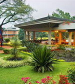 |
Crowne
Plaza Hotel Kathmandu-Soaltee
Nestled in the Himalayas
of Nepal, Soaltee Crowne Plaza is the leading five star deluxe hotel in
Nepal offering a Resort atmosphere and is ideal for both business and leisure
travel. Spread over 11 acres of lush green lawns, the hotel is located
in the quiet green suburbs of the city with fabulous views of the mountain
ranges. With 283 well appointed rooms ranging from Deluxe, Club to Suites
the hotel proudly holds ground to its set of seven Regal Suites each with
unique decor. The traditional grace of inherent Nepali culture, seamless
service is not a dream anymore when you aspire to be a guest at the hotel. |
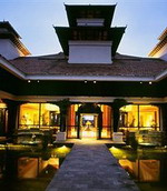 |
Hyatt
Regency, Kathmandu
Hyatt Regency Kathmandu
is a luxury 5 star city resort hotel situated 10 Km from the city centre
of Kathmandu, Nepal, on the road to Boudhanath Stupa - the most holy of
Tibetan Buddhist shrines outside Tibet. The hotel is 4 Km from Tribhuvan
International Airport and very close to the business district and shopping
areas. The Boudhanath Stupa is within ten minutes walking distance from
the hotel. The hotel is also host to Club Oasis Spa, a sanctuary of calm
in Kathmandu, Nepal. |
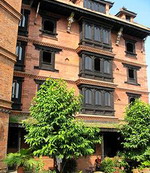 |
Kantipur
Temple House, Kathmandu
Centered in Kathmandu, Nepal,
the Kantipur Temple House, built in traditional architecture, is located
in Thamel and is close to major sightseeing areas like Kathmandu Durbar
Square, Swayambhunath Temple. Guests are close to the Hanuman Dhoka Square,
where real monkeys live and thrive in the place built to honor the mischievous
and courageous monkey god Hanuman. Against the backdrop of mountains, the
hotel presents a traditional Nepali ambience with architecture, carved
wood, brick walls, and fountains. A rooftop garden restaurant, which along
with the main dining hall, offers Nepali, Indian, Chinese, Thai and continental
fare and offers views of the mountains, Swayambhunath Stupa, and the city. |
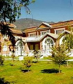 |
Park
Village Resort, Kathmandu
An eco-friendly hotel with
all-suit-room, built in duplexes and spread in 4 acres of woodland with
lots of birds and butterflies at the foothill of Mountain Wildlife Reserve.
A unique homely hotel that gives a sense of "Living in Pure Nature right
in metropolis Kathmandu". Spread in 5 acres of wooded land, Park
Village Hotel offers 48 unique studio type accommodations with all modern
amenities including fireplace in seven separate Bungalows namely Magnolia,
Maple, Pine, Lavender, Orchid, Jacaranda, and Jasmine. Farmhouse cafe caters
to speciality Nepali, Indian & Chinese cuisine. Earth Watch Restaurants
serves the daily buffet with extensive menu. Waterhole Bar: a perfect setting
for evening cocktails & getting togethers |
Continue
browsing hotels in Kathmandu
Top
Bangladesh
- Cambodia - China -
Georgia
-
Hong Kong - India
-
Indonesia & Bali - Japan
-
Kazakhstan
- Korea (South) - Kyrgyzstan
- Laos - Macau - Malaysia
-
Maldives - Nepal -
Pakistan
-
Philippines
- Singapore - Sri Lanka
- Taiwan - Thailand
- Turkmenistan - Uzbekistan
- Vietnam
|